Amenities along the Tamiami Trail (U.S. 41) between Naples and Miami
CURRENT CYCLING CONDITIONS on US41 from Naples to Miami
General
-- Entire road is 2-lane with high speed traffic and narrow bridges
-- Miles listed on map are # miles from Collier Blvd (951) in Naples to Krome Ave in Miami
-- Trailheads have parking & toilets (no drinking water). Visitor Centers have drinking water.
-- summer conditions: be wary of thunderstorms in the afternoons
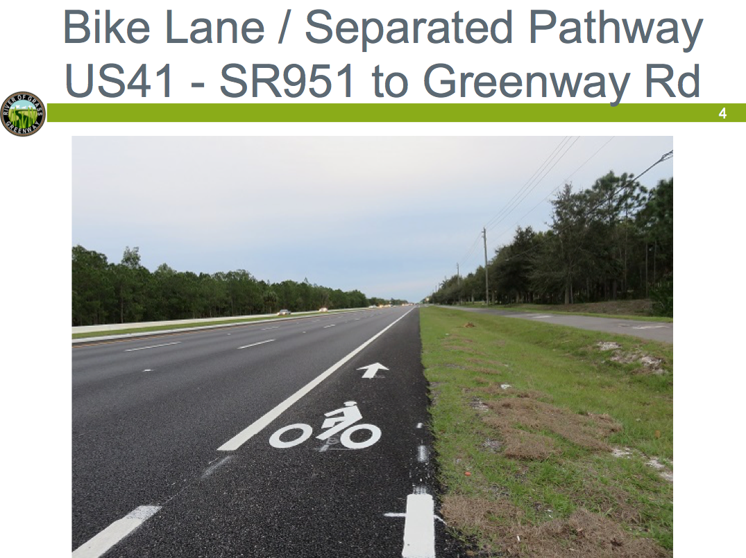
West (updated January 2023)
-- On US 41, 3-mile section closest to Collier Blvd. was 6-laned in 2015. Bike lanes and multi-use pathways were included in project. Caution: on the north side, narrow walkway used mostly for pedestrians.
-- the 2-mile gap between Greenway and 6L Farm Roads is the “missing link” for a separated pathway which is scheduled to be constructed as funding becomes available and the road section is widened to 4 lanes
-- the 2.3 mile separated multi-use pathway on the south side from 6L Farms Road to San Marco Road (CR92), just west of Collier Seminole State Park, was completed October 2016. In 2022 construction work began just west of CR92 to install culverts to improve water flow; this will continue through 2023. Barriers include a protected bike path on the south side of the road so cyclists are able to ride safely through this area. There is a jog back onto US41 at the Alexander-Cameron Canal bridge so be cautious about sharing the road.
-- CR92 (to Marco) has no shoulder; traffic volume low off-season; high speed; be cautious of trucks hauling wide boat trailers; traffic volume higher on weekends and in winter season.
-- The raised pavement markers (RPMs) between CR92 and Port of the Islands have been removed from the shoulders; for safety, new white striping with the audible/vibratory markings along the shoulder edge have been installed.
-- miles 14-25 (between Port of the Islands and SR29) was resurfaced early 2016. Resurfaced shoulders are great.
-- miles 25-31 paved shoulder (4 ft) is sometimes rough; Narrow bridges. CAUTION.
Central (updated January 2023)
-- Hwy 29 north to Immokalee & south to Everglades City has wide shoulder.
-- Welcome Center at Carnestown (US41 / SR29) is closed. Visitor Information Center is open in Everglades City at 207 West Broadway 7 days a week from 10 am to 2 pm. Visit website www.visitevergladescity.com for complete information. Everglades City is a designated Florida Trail Town and has many amenities and a bike repair station located in the city park.
-- long distances between water/food sources. Water, soda, snacks for sale at Big Cypress Swamp Visitor Center (mile 27.5); they close at 5 pm. Big Cypress Oasis Visitor Center (mile 46) is currently closed.
-- Trail Lakes Campground (mile 29.5) also has water, soda, snacks AND ice cream.
-- pavement shoulders widened to 4 ft throughout ROGG-central in 2013. ...bikeable (yeah! -- thanks FDOT).
-- at MM37 the Miccosukee Information Center is temporarily closed and the Miccosukee Restaurant is permanently closed.
-- alternative route (mile 42 & mile 60.6) is Loop Rd. Western portion is packed limerock, possibly rough with puddles in summer wet season; skinny tires NOT recommended; Eastern portion paved.
East (updated January 2023)
-- miles 56-60 resurfaced in 2014; miles 60-64 resurfaced in 2017; 4 ft wide paved shoulders; raised pavement markers when approaching narrow bridges were re-installed with resurfacing of road; can be hazardous to cyclists. CAUTION at narrow bridges.
-- construction of the two new bridges was completed December 2018 with wide 10' paved shoulders; construction work has begun to continue the restoration of the Everglades which will include an elevation of 6.5 miles between the bridges and six new culverts; this section is currently in the design phase. Current construction activity (about 1.5 miles west of Krome Avenue) includes preparing the work zone east of the ValueJet Memorial to just east of S-334. Construction for the temporary widening along the north side of Tamiami Trail between Airboat Association of Florida and the S-334 control structure for the upcoming traffic shift. Operations will take place between 9 am and 4:30 pm, Mon-Fri. Work will be done in stages to minimize construction-related impacts. Additional information is available by contacting Community Outreach Specialist Heather Leslie at 305-905-5876 or email her at Heather@hmlpublicoutreach.com. Drivers are encouraged to call 511 before they drive, or log onto www.fl511.com to get real-time traffic and lane closure information.
-- 1-mile bridge opened in 2014. It has 10-ft paved shoulders; be cautious of drainage grates. Alternative route is rough gravel road on levee north of highway. note: access to levee road only at Mile 61, 66 (foot bridge), 71.
-- Krome Avenue - The Florida Department of Transportation (FDOT) has completed the final segment of a roadway construction project along SR 997/Krome Avenue from SW 232 Street to SW 136 Street which began in January 2019 and featured approximately $37.8 million in roadway expansion and safety enhancements. Construction project to widen the road began in February 2015 with a separated pathway (on east side) for 8.5 miles south of US41, then switches to west side.
• see mileage chart for more precise distances between facilities
________________________________________________________________
• read Pieter's story about off-road cycling across South Florida
• read Justin's story about cycling US41 in March 2017
• read Oscar's story about cycling the Tamiami Trail in November 2016
• read JJ's story about cycling US41 in September 2009